Showing posts with label Snow Cover. Show all posts

Friday, November 27, 2020

Detection and validation of spatiotemporal snow cover variability in the Himalayas using Ku-band (13.5 GHz) SCATSAT-1 data

A Scatterometer is a microwave radar instrument designed specifically for ocean Applications. Although due to strong sensitivity to wetness in snow, it has been extensively used for the cryosphere applications such as extraction of snow parameters, With Scatterometers, the accuracy and complexities of snow detection algorithms are the major concerns as compared to optical data (multispectral) based algorithms since snow is more separable using visible wavelengths as compared to microwave wavelengths. But optical data are limited to cloud-free days and this is an important advantage of microwave data as compared to optical measurements where practically any cloud limits the exact characterization of the land surface state. 

Some glimpse of study

The present study evaluates the potential of Ku-band Scatterometer Satellite-1 (SCATSAT-1) for quantification of spatiotemporal variability in snow cover area (SCA) over Himalayas(Himachal Pradesh) India. The SCA has been measured using dual-polarized (HH and VV) backscattered SCATSAT-1 data. Two classification approaches, i.e., Linear Mixer Model (LMM) and Artificial Neural Network (ANN) model have been used for the present study. Both available backscatter coefficients sigma-naught σ0 and gamma-naught γ0 have been considered for the estimation of SCA. To compute the seasonal snow cover trends for winter (2016‒2017 and 2017‒2018), a post-classification comparison (PCC) based change detection approach has been demonstrated on the classified dataset (LMM and ANN). The SCA maps have been validated using reference snow cover maps generated from the Moderate-resolution Imaging Spectroradiometer (MODIS) sensor. The final change-category maps have effectively mapped the snow cover variations with accuracy in between 83.01% and 95.33%. The results indicate the suitability of SCATSAT-1 for estimating the magnitude of snow extent over the Himalayas.

Reference: S. Singh, R.K. Tiwari,. V. Sood, H. S. Gusain, Detection and validation of spatiotemporal snow cover variability in the Himalayas using Ku-band (13.5 GHz) SCATSAT-1 data, International Journal of Remote Sensing, Taylor and Francis, 2021.

Link for full study:
https://doi.org/10.1080/2150704X.2020.1825866

Tuesday, October 13, 2020

Monitoring and mapping of snow cover variability using topographically derived NDSI model over north Indian Himalayas during the period 2008–19

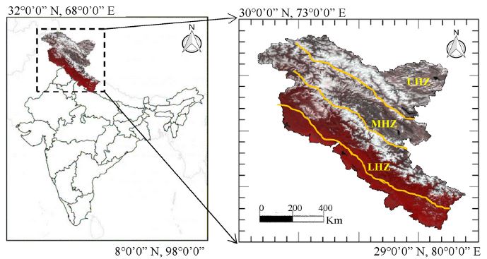
The Himalayas is an essential component of the cryosphere due to the large extent of snow or ice cover. The mapping and monitoring of snow cover variability over the Himalayas is the focus of many scientific studies due to the major source of water for Asian countries and equally important for climate change studies. This study describes the analysis of snow cover variability over North Indian Himalayas (NIH) covering Western Himalayas and Karakoram mountain ranges. The snow cover area (SCA) has been analyzed in three different climate zones such as the upper Himalayan zone (UHZ) (Ladakh and Karakoram range), middle Himalayan zone (MHZ) (Great Himalaya and Zanskar), and lower Himalayan zone (LHZ) (Pir Panjal and Shamshbari range) at various elevation levels as well as aspect levels during the past decade (2008–2019). The snow cover maps have been generated for NIH and its climate zones from Moderate Resolution Imaging Spectroradiometer (MODIS) data. 

Glimpse of Study

The global climate change is directly or indirectly impacting the regional climate of the Himalayas and thus, requires more attention to seasonal or inter-annual snow cover variations over the mountainous region. In the present work, the focus is on analyzing the seasonal snow cover variability at different elevations (LHZ, MHZ, and UHZ) and aspect levels (N, NE, SE, S, SW, W, NW) during the last decade (2008–2019). The NIH experienced global warming effects especially at lower and middle Himalayan zones which can be observed as shifting of snowmelt runoff and snow accumulation periods. The experimental outcomes suggest that shifting of this period are generally due to an increase in temperature over the Himalayan mountain range. The seasonal and annual trend analysis has shown that seasonal snow cover is varying across different elevations and geographical extent. The results computed in the present study have some limitations such as lack of incorporating precipitation data and in-situ or field observations. Therefore, the comparative analysis of different model outputs delivers important information regarding the impact of climate change over the snow cover area. This study also provides effective guidance in the prediction of natural hazard analysis and the protection of water resources.

For detailed Study:
Sood, V., Singh, S., Taloor, A.K., Prashar, S. and Kaur, R., 2020. Monitoring and mapping of snow cover variability using topographically derived NDSI model over north Indian Himalayas during the period 2008‒19. Applied Computing and Geosciences. https://doi.org/10.1016/j.acags.2020.100040